

CIR 06/26 | Guidance on the use of the recently launched Land Registration System (LRS)
As many of you will be aware following our previous circular, the Land Registry Agency (LRA) launched its new digital platform for the acquisition of site plans and the submission of Form E requests.
Unfortunately, the launch was somewhat rushed, with little opportunity for thorough explanations for members of the profession to understand the functionalities of the new system, and to continue to ensure high standards in the preparation of relative official documentation.
This circular is intended to provide advice on how to proceed in the short term, together with some contextual information we did not provide thus far.
Background
The digitalisation of the Land Registry system has been in the works since 2019. Indeed, various representatives of the Kamra, including members of the Council and the Policy Committee on Property, have been attending meetings with senior officials at the Land Registry Department and, later, the Land Registry Agency, at very preliminary stages right until a few days before the formal launch.
One of the main features of the proposed system was that periti would be able to plot “polygons” representing the boundary of a property subject to a deed. Such polygons would be drawn using a mouse and snap to lines on the basemaps.
While welcoming the digitalisation process, KTP representatives have always expressed deep reservations about snapping to basemaps that were infamously inaccurate. Regardless, basemaps can never provide the level of accuracy that has become expected of periti in recent years.
The Kamra’s solution has been to provide either, or ideally both, of the following options:
- Keying in georeferenced coordinates of points to indicate the site boundary into the Land Registry platform;
- Uploading polygons drawn on CAD in DXF format, preferably georeferenced, or alternatively having the possibility of controlling the position of the uploaded DXF polygon relative to a corner on the basemap.
Unfortunately, by the time the system went live, neither of these options had been programmed into the software.
However, the LRA provided a third option: the download of site plans in PDF format, against payment, for periti to annotate using their software of choice, as they currently do with Planning Authority site plans. LRA site plans can be printed with digital markings applied by periti and authenticated in wet ink.
Alternatively, they can continue marking them by hand in ink as they have always done thus far.
The watermarking of site plans will no longer be required.
It is pertinent to underscore that, due to contractual deadlines, the previous website through which the LRA sold site plans needed to be shut down on Wednesday, 5th August 2026.
It was thus imperative that a compromise on an alternative solution was found.
The Council noted that the ability to acquire site plans in PDF format, rather than having physical plans mailed by post, and the possibility to mark them digitally, ensured that:
- Periti could provide their services far more efficiently;
- The precision and presentation of annotations and markings on site plans would be significantly improved;
- The same digital site plan can be reused for various deeds, reducing costs.
It is on these grounds that, following a detailed presentation by LRA management to the Council, the latter agreed to support the transition to the new Land Registry System (LRS).
Professional Practice Recommendations
Please find below the Council’s recommendations pursuant to the newly launched LRS:
- Members of the profession are advised NOT to mark polygons on the online system for the purposes of preparing site plans intended for the registration of deeds, due to the risk of imprecisions and overlaps, until the Kamra’s recommendations discussed above are introduced by the LRA.
- Periti may choose to prepare physical site plans as outlined above, or proceed with the preparation of polygons for the purposes of Form E applications typically submitted by notaries, since the level of precision in such exercises is not as important. Periti may wish to note that this will replace the commonly adopted practice of annotating site plans as “Not for registration purposes” or other such similar annotations, when the site plans are created solely for the purpose of notarial searches.
Acquiring a site plan
Site plans can be acquired by zooming in on the plot of land to be registered, and clicking on the burger menu at the top-right corner of the map, as shown in Figure 1.
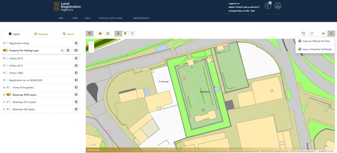
Periti can then select their preferred scale from the menu on the left-hand side of the screen. The scale printed on the right side of the site plan will remain 1:2,500 as per usual.
Information session
The Kamra tal-Periti is in discussions with the LRA to hold a training session for periti in early September, to go through the full functionalities of the new LRS, as well as the launch of new guidance on the preparation of Land Registry site plans — including in apartment blocks and complexes — which is being drafted in consultation with the Kamra.
Bugs in current version of LRS
Following the launch of the LRS last week, the Council has received feedback from various members of the profession highlighting bugs they came across when using the software. These included:
- A serious GDPR flaw when trying to virtually add office members, with personal data of everyone registered on the system accessible;
- Missing periti on the platform;
- Inability to add non-periti to virtual LRS offices.
We are aware that the LRA is working round the clock to resolve these matters, some of which may have already been addressed by the time you read this circular.
If you identify any other bugs in the software, please contact us at [email protected] or through the Periti Discussion Group on Facebook.

